Hurricane Zeta Wallops Louisiana Coast
As predicted, the storm grew into a Category 2 hurricane, with all the bad stuff associated with that. And it’s on the move.

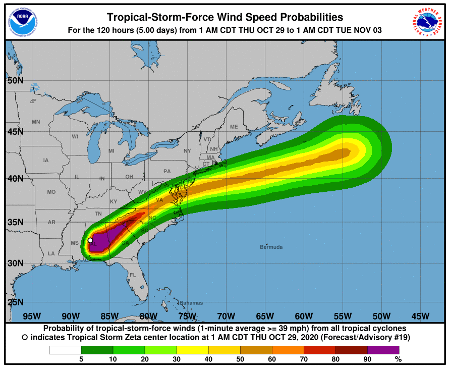
Hurricane Zeta slammed into the Louisiana coast on Wednesday and began its push inland. Pilots are urged to use caution, and check weather and Notams carefully, if they're flying in the vicinity of the path of the hurricane. The illustration shows the projected wind speeds of the major storm and its probable path.
With winds of 110 mph when it made landfall near Cocodrie, Louisiana, storm watchers called Zeta a "strong Category 2" hurricane. There were two factors that will make its march northeast damaging and wet.
The first is that the storm stalled and grew before making its way across the Gulf, where warmer-than-normal water temperatures accelerated its growth. The storm has also maintained much of its power as it moved quickly, at an estimated 35 mph---fast for a big storm---up through Louisiana and into neighboring Mississippi. It's expected to continue north and eastward as it dumps large amounts of rain and bring strong winds as it makes its way to northern Georgia.
The damage to the city of New Orleans, Louisiana, was less than feared, even though the storm made landfall just to the west of the city, which is vulnerable to flooding, as we all know from the devastating Category 5 Hurricane Katrina in 2005. New Orleans got just 2.5 inches of rain with Zeta, though one resident was killed when they came into contact with a power line downed by high winds.
We'll keep you updated as we learn more about the impact of Zeta, especially to aviation facilities.

Subscribe to Our Newsletter
Get the latest Plane & Pilot Magazine stories delivered directly to your inbox


