
Learning To Fly In A Cirrus SR22 Part II
Navigating cross-country with a glass panel
According to Cirrus, the all-glass panels in their planes make learning to fly easier and safer than with the round gauges that pilots have used since almost the beginning of aviation time. We weren't so sure, so we put their claims to the test. I was to earn my private pilot license in a Cirrus SR22. ---Plane & Pilot, November 2006

After having successfully completed several solo flights in the Cirrus SR22, I entered the next phase of my private pilot training: cross-country navigation. My concerns as a student pilot in a glass-panel cockpit were twofold: would the state-of-the-art avionics be overwhelming; and if not, would I become so dependent on them that I wouldn't be able to navigate with an "old school" sectional chart?
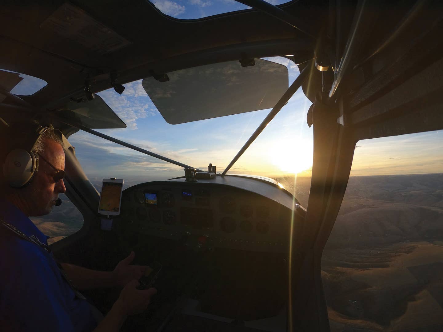
Avidyne Entegra's primary flight display (PFD) contains the standard "six-pack" of instruments, and the multi-function display (MFD) has an abundance of information, from electronic checklists to moving maps, airport charts and engine monitoring parameters. "Learn to fly first," advised several pilots. "Then you can figure out all that fancy stuff." But was there anything wrong with doing both at once?
Dual Training
My instructor, Liz DeStaffany, selected Big Bear City Airport, 80 nm east of Justice Aviation (our flight school at Santa Monica Airport in Southern California), as the destination for our first dual cross-country trip. At an elevation of 6,750 feet on the opposite side of the Los Angeles Basin, Big Bear would provide a good learning experience through congested airspace as well as an introduction to mountain flying in the Cirrus.
In spite of the flight management system's "fancy stuff," I still had to---of course---plot my course on the sectional and write out a navigation log, calculating headings, speeds and fuel burn based on wind reports from a weather briefer. In flight, I could later compare my estimates to readings on the PFD and MFD. The Big Bear AWOS was reporting density altitude as 8,500 feet, but even with full fuel, our 310 hp high-performance aircraft was well within its performance capabilities.
Our planned route went under Class B airspace, through Class D and over Class C. This would necessitate a few quick climbs and descents, which the SR22 could handle easily, but most importantly, it would require accurate situational awareness. Although the dual Garmin 430s take some getting used to, they're extremely useful tools that provide a wealth of information. Navigation and flight plan information entered into the GPS/Nav/Comm units cross-feed into the Avidyne system, which displays corresponding data such as airport diagrams on the chart page of the MFD, and overlays the direct course on the PFD's HSI. In addition to selecting radio and VOR frequencies on the 430s, I input a flight plan to Big Bear, creating waypoints from en route airports listed in my navigation log. This would help in making precise position reports on the radio.
Feeling confident, I preflighted, started the engine, and we were on our way---or were we? As the MFD came to life, an unfriendly red circle glared from the moving map: a dreaded TFR, which hadn't been mentioned by flight service. The Avidyne system, which receives real-time information via satellite, will sometimes display TFRs early. To be sure, we confirmed with the tower that the TFR in question hadn't yet been activated. Better safe than sorry!
Once airborne, it was great to have the moving map in the congested airspace of the Los Angeles Basin---but, as tempting as it was to rely on it, I tried to think of it as a bonus. Every once in a while, Liz would turn the map off to drive home the point that students should know where they are, independent of avionics.
Skywatch traffic alerts (displayed on both the Avidyne and Garmin 430) were reassuring, although it was frustrating that they constantly defaulted to filter for "above" traffic only. I often forgot this, falsely assuming that my previous setting of "unrestricted" was still selected and that the traffic displayed was a complete picture.
Leaning the mixture in the Cirrus is straightforward and precise, via the "lean assist" tool on the MFD's engine page. As you lean, it indicates when the first peak has been detected, and simple messages guide you toward the correct mixture setting, be it for best power or best economy. Once the engine lean setting is established, you can select a view of "normalize" (which displays any ensuing variations) or "absolute" (which displays actual temperatures).
After the successful leg to Big Bear, Liz instructed me to perform a short-field takeoff on departure, because of the density altitude and surrounding mountains (even though the runway was a lengthy 5,850 feet). Holding the brakes, I applied full power and anticipated a lot of right rudder upon release. On the takeoff roll, we reached 60 knots almost immediately, but acceleration to Vr (70 knots) gave an illusion
of slow motion. I climbed out gradually, for added safety.
On the way home, we used the inverse function on the Garmin 430---one of my favorite features---to reverse the flight plan. This eliminated the need to reenter each waypoint manually, a sometimes painful process. With the sun in our eyes, we couldn't discern haze from clouds, but we verified our weather briefing via the MFD's satellite datalink, which overlays NEXRAD, METARs, AIRMETs and SIGMETs on the moving map.
Going Solo
When the time came, Liz chose Paso Robles Municipal Airport (146 nm northwest of Santa Monica) and Mojave Airport (126 nm east of Paso Robles) for my long solo cross-country flight. One of the perks of the SR22---because of its high speeds---is the option to cover longer distances during training, exposing the student to more real-world conditions.
Although my flight plan was in the Garmin 430, I made sure to keep a finger on the good old sectional chart to practice pilotage skills. I double-checked my work with the moving map, and navigated using a combination of landmarks, VORs and the GPS course. At around 70% power, groundspeed was approximately 160 knots. Although many Cirrus pilots rave about the autopilot, Liz always had me fly by hand. The cross-country legs allowed time to master the trim, which I had struggled with in the beginning of my training.
Nearing Paso Robles, I monitored CTAF and ASOS to determine which runway was active. No matter how much Liz and I had studied uncontrolled airports, I still had nightmares about messing up the pattern. But thanks to the PFD's wind indicator (which shows wind direction and velocity), I confirmed the best runway. After completing the before-landing checklist on the MFD, I announced my intentions and touched down with a sense of accomplishment.
But my excitement was short-lived, as it became apparent that all of the tiedown spots at transient parking were taken. Setting the record for the world's slowest taxi ever, I eventually scored a spot when another aircraft departed. After a stop at Matthew's at the Airport (www.matthewsattheairport.com) for a sandwich (delicious---no wonder parking had been full), I departed for Mojave. Once airborne, I treated myself to music on the XM Satellite Radio, which is controlled via remote control and automatically silences for radio transmissions.
Short final at "America's first inland spaceport" was an impressive sight, with countless airliners stored in the dry desert and tire marks telling tales of pioneering airplanes such as the Global Flyer and SpaceShipOne. Unlike Paso Robles, there were no other aircraft at transient parking; it felt as if I had arrived at an aviation ghost town populated with sleeping 747s.
As I relished the solitude, an out-of-nowhere roar erupted from a MiG fighter jet zooming low to the ground at top speeds. It repeated the pass several times as if to perform a private air show. I didn't want to leave this land of mysterious jets, but there were still 64 nm of the return leg beckoning my call sign. As the Cirrus and I lifted off, we rocked our wings to the dormant giants below and turned toward home.
Although some of the fears I once had about training in a Cirrus SR22 did surface, it became apparent that they were conquerable. A faster aircraft is more challenging and requires extra training, but students learn according to the level of their aircraft. (And if it's going too fast, pull back on the throttle!) The Avidyne Entegra is not a video game, but a great resource from which information can be pulled, as needed. When all was said and done, the hardest part of my solo SR22 journey had been finding an available tiedown at Paso Robles on a nice Sunday afternoon!
Back at Justice Aviation, Liz and I discussed the upcoming portion of my training: preparation for the big checkride.

Subscribe to Our Newsletter
Get the latest Plane & Pilot Magazine stories delivered directly to your inbox